
2018 November 4
The visibility of rockets and missiles launched from Vandenberg AFB varies greatly. Some launches are difficult to see from relatively short distances while others are visible for several hundred miles. There are four primary factors affecting visibility:
In order for a launch to be visible from a given location, it has to be above the observer's horizon at some point. The visibility footprint for a launch is controlled by the vehicle's trajectory or flight path. Of primary importance are the direction of launch, steepness of the flight path, and the vehicle altitude during the powered phase.
With the exception of the Pegasus XL, all Vandenberg AFB launches take place from the base. Minuteman III missiles climb rather steeply and head due west. Delta, Taurus, and other satellite launch vehicles fly towards the south and climb more slowly.
Pegasus XL launches are staged from Vandenberg AFB, but actually occur offshore. An L-1011 jumbo jet carries the Pegasus from Vandenberg to the release point 39,000 feet (11,887 M) above the Pacific and 70 miles (113 km) southwest of Monterey. After launch, the Pegasus rocket heads south and gradually gains altitude.
Lighting conditions have a tremendous effect on launch visibility. Daylight launches are visible for distances from 10 to more than 195 statute miles (16 to more than 314 km) while those at night are often visible for more than 300 statute miles (483 km).
Twilight launches are often the most impressive. If the conditions are right, the Sun is below the observer's horizon and sunlight illuminates the vehicle's contrail and exhaust plume, creating a display visible for distances of several hundred miles.
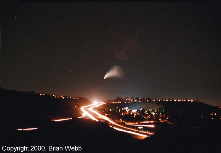
This time exposure is a good example of the distance from which twilight launches are sometimes visible. It shows the fourth stage exhaust plume from a Minotaur rocket more than 1,500 statute miles (2,414 kilometers) away. Liftoff occurred long after sunset and the ground was in darkness, but the missile had climbed high enough to be illuminated by sunlight when the webmaster took this photo from Ventura County, California.
The lighting conditions, and therefore launch visibility, can be different for the same launch from different locations. For example, if a missile lifts-off from Vandenberg AFB in the late afternoon, the Sun is above the horizon in California, limiting the launch's visibility for observers on the West Coast. However, for observers further east, the Sun is below the horizon and they may enjoy an impressive twilight display.
The visibility of Vandenberg launches varies with the type of launch vehicle and is the result of the type of propellant used and the amount burned during a given unit of time.
Pound for pound, solid fuel radiates much more light when it burns than does liquid fuel. When solid fuel burns, it is so bright it resembles a road flare. Solid fuel also produces a continuous smoke trail during the entire burn time. Liquid fuel engines, however, produce a much fainter flame. It can be so faint that it is almost invisible in daylight. Unlike solid fuel rocket motors, liquid fuel engines do not continuously produce a smoke trail. Instead, they briefly leave a vapor trail when they pass through the stratosphere between 33,000 to 38,000 feet (10,058 to 11,582 M).
The amount of propellant burned during a given unit of time varies with the launch vehicle. For example, the Minuteman III and the now retired Peacekeeper both burned solid fuel, but Peacekeeper launches were more visible because the vehicle burns more fuel per unit of time.
The rockets and missiles launched from Vandenberg AFB use solid fuel rocket motors, liquid fuel engines, or a combination of both. The visibility of the various vehicles is ranked as follows:
| Visibility | Vehicle | Comments |
|---|---|---|
| Greatest | Delta II | Ranking only applies to the first stage burn of a Delta II using nine solid rocket motors |
| --- | Minuteman II and III, Athena, Taurus | The now retired Peacekeeper was included in this group |
| Least | Pegasus XL | Can be spectacular if the lighting is correct |
Atmospheric transparency refers to the clarity of the air mass between the rocket or missile and the observer. Although clouds can obviously prevent you from seeing a launch, haze and smog are also potential problems. This is especially true for daylight launches. Daylight launches are often difficult to see to begin with, but haze and smog can further reduce the contrast between the vehicle smoke or vapor trail and the sky background.
The atmospheric clarity of southern and central California depends on the time of year and varies with the region's two distinct weather patterns. The cooler months experience a variety of weather conditions - storms, Santa Ana winds, etc. The location and extent of cloud cover is variable and clouds occur at a wide range of altitudes. There is much less haze and smog, resulting in good to excellent horizontal visibility.
During the warmer months, the weather is fairly predictable. Coastal low clouds frequently plague the coast and areas several miles inland. When coastal clouds occur, they form just offshore and begin to move inland during the afternoon or evening. The cloud layer moves further inland and thickens during the next several hours. It reaches its furthest distance inland and greatest thickness just before sunrise. The cloud layer typically extends up to about 1,500 feet (457 M) in Santa Barbara and at Vandenberg AFB and up to 2,000 feet (610 M) in Orange County and San Diego1, 2.
The probability of overnight coastal cloud cover during the summer varies from about 60 to 70% depending on the location, with Vandenberg AFB falling in the middle of this range3. However, the interior tends to be clear.
The following table summarizes the atmospheric transparency for different times of the year:
| Parameter | October-April | May-September |
|---|---|---|
| Cloud Cover | Variable in location and extent. Occurs at a range of altitudes |
Location and extent predictable. Frequent coastal low clouds and fog up to 2,000 feet (610 M). The interior is clear |
| Horizontal Visibility | Variable, but typically very good | Less variation, but with more haze and smog |
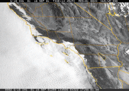
This satellite image shows the low clouds frequently present along the California coast during the warmer months. Image courtesy of National Weather Service
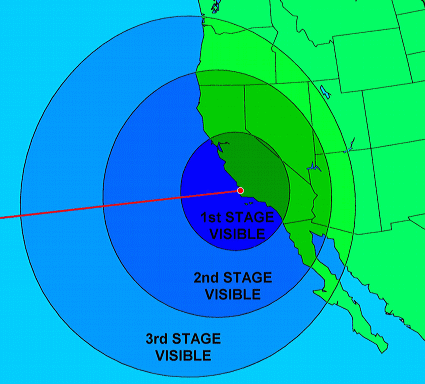
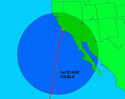
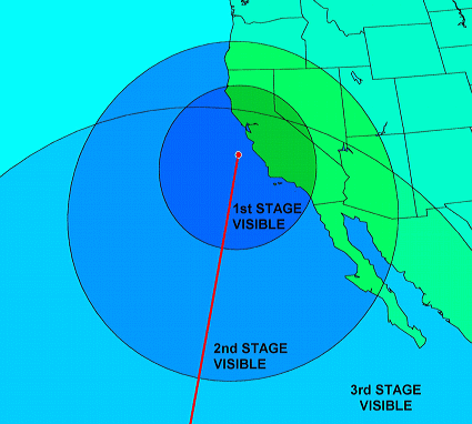
Probably the most frequently asked question regarding Vandenberg launch viewing is if an upcoming launch will be visible from a given location. Space enthusiast Rick Baldridge used data derived from amateur launch imagery and processed it with Rob Matson's SkyMap to generate representative visibility plots for the three general types of Vandenberg launches: ballistic, satellite, and Pegasus XL. When generating the plots, Baldridge limited the area of visibility to those locations where the vehicle attains an elevation of 2.0° or more above the horizon.
Visibility footprint for night and twilight Minuteman III test launches to the central Pacific. Copyright 2005, Rick Baldridge.
Footprint for a Delta II carrying a satellite into a sun-synchronous orbit. The plot assumes a night or twilight lift-off with a launch azimuth of 190°. This plot is based on the trajectory of the 2004 Delta II/AURA launch. Although several types of boosters are used to launch satellites from Vandenberg AFB, the Delta II is the most frequently employed. Copyright 2005, Rick Baldridge.
This plot shows the visibility footprint for a night or twilight Pegasus XL launch to place a payload into a sun-synchronous orbit. The launch azimuth is 188°. The plot is based on the trajectory of the 1999 Pegasus XL/WIRE launch. Copyright 2005, Rick Baldridge.
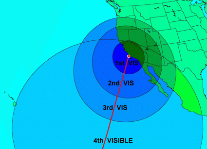
Footprint for a Minotaur carrying a satellite into a sun-synchronous orbit. The plot assumes a night or twilight lift-off with a launch azimuth of 200°. This plot is based on the trajectory of the 2000 Minotaur/JAWSAT launch. Copyright 2005, Rick Baldridge.
Information on upcoming Vandenberg AFB rocket and missile launches is available from a variety of sources. The following are the most reliable:
Space Archive Web Site
www.spacearchive.info
www.spacearchive.info/vafbsked.htm
Space Archive lists all Vandenberg AFB rocket and missile launches for the next six months and the status of pending launches.
Launch Alert Newsletter
mailman.qth.net/mailman/listinfo/launch-alert
Launch Alert is a free, e-mail based newsletter that publishes a schedule of all Vandenberg AFB launches as well as reminders of pending launches and pre-launch status.
Spaceflight Now Web Site
www.spaceflightnow.com
www.spaceflightnow.com/tracking/index.html
This site contains a detailed listing of all satellite launches worldwide - including those scheduled from Vandenberg AFB. However, it does not list ballistic (non-orbital) launches (Minuteman III and missile defense tests). Probably the most important features of this site are the countdown status reports it provides for pending U.S. launches and the running countdown commentary that begins at about T-1 hour.
NASA TV
www.nasa.gov/ntv
NASA TV usually provides live coverage of NASA satellite launches via satellite and the Internet.
Contractor Video Feeds
Launch vehicle or payload contractors may provide launch coverage over the Internet or via satellite. Consult company press releases or public relations personnel for more information.
Boeing Delta Launch Hotline
714-896-4770
Boeing provides recorded messages with the status of Delta missile launches from Vandenberg AFB, Kennedy Space Center, and Cape Canaveral Air Force Station. This is an excellent, but often overlooked source of information.
The probability that a launch will occur as scheduled depends on the launch type and the time of year. Minuteman III test launches usually occur on the first attempt and on time because ICBMs are highly reliable and are largely unaffected by weather.
Satellite launches (Delta II, etc.) are sometimes postponed at the last minute due to problems with the booster. When these launches are scheduled for October through February, they face an additional risk of cancellation due to weather problems such as upper level winds and layered clouds.
Vandenberg AFB rocket and missile launches are often visible across a wide area without any special effort. However, for the best view, it will probably be necessary to travel to a suitable observing site. The ideal site would have the following characteristics:
The Southwest contains numerous sites suitable for launches. The following are a few locations that the webmaster has visited.
Vandenberg AFB
| Latitude: | 34° 42' 33" (34.709°) N |
| Longitude: | 120° 36' 00" (120.600°) W |
| Elevation: | 100 ft (30 M) |
| Access: | Closed to the public |
| Contact: | Public Affairs 805-606-3595 |
Depending on the weather, Vandenberg AFB is either the best or the worst place to view a launch. During the warmer months on the year, coastal low clouds are a major problem. However, the base is so large that the climate varies depending on the location.
On most days from May through September, South Vandenberg has more low cloud cover and fog than virtually any other portion of the California cost. The sky clears for a few hours in the late morning to early afternoon before the low clouds and fog return.
The weather during the warmer months is much better at north base. Low clouds and fog are still a problem, but they are less frequent and occur between late evening and mid-morning. The sky is often clear from late morning until well after sunset.
Santa Ynez Peak
| Latitude: | 34° 31' 36" (34.52666°) N |
| Longitude: | 119° 58' 45" (119.97916°) W |
| Elevation: | 4,200 ft (1,280 M) |
| Access: | This is technically a restricted area located within publicly accessible federal land. An Adventure Pass may be required. |
| Contact: | U.S. Forest Service |
This is often the best viewing location. It is high enough that it is usually above coastal fog, low clouds, and haze, and it is fairly close to the base. To get there, follow these directions:
DANGER
These mountain roads have steep drop-offs and no guardrails. Not paying attention to your driving for only a second could kill you. Watch out for ice and loose gravel on the road and be very careful when you back up your car.
East Camino Cielo
| Latitude: | 34° 30' 57" (34.51583°) N |
| Longitude: | 119° 46' 43" (119.77861°) W |
| Elevation: | 3,000 ft (914 M) |
| Access: | Located in publicly accessible national forest. Adventure pass required |
| Contact: | U.S. Forest Service |
This site is located in the mountains about six miles (10 km) northwest of downtown Santa Barbara. Although not as close to Vandenberg AFB or as high as Santa Ynez Peak, this site is easier to get to, open to the public, and in many cases, is a shorter drive. To get there, do the following:
If you are driving from the Santa Ynez Valley, Solvang, or areas further north, do the following:
If you are driving from Santa Barbara, Goleta, or areas further south, do the following:
Del Cerro Park
2 Park Place
Ranch Palos Verdes
| Latitude: | 33° 45' 40" (33.76111°) N |
| Longitude: | 118° 22' 30" (118.3750°) W |
| Elevation: | 1,190 ft (363 M) |
| Access: | Public park. Closed dusk to dawn |
| Contact: | (310) 544-5260 parks@rpv.com |
This is a good site, but rooftops may partly obscure the horizon in the direction of Vandenberg AFB. The directions to this site are as follows:
Knowing where to look involves determining where the vehicle will appear above the horizon with respect to your viewing location. For observers within a few hundred miles of the launch site this is fairly easy since the direction to the launch site and where the rocket or missile will appear are basically the same.
However, for observers in outlying areas, the direction to the launch site and where the vehicle will appear, can be quite different. Knowing where to look from these areas requires knowing the direction to the launch site, taking into account the rocket or missile's direction of flight and how steeply it will climb (refer to Vehicle Trajectory), and making an educated guess where it will appear.
The following table lists the azimuth (direction) to Vandenberg AFB and the Pegasus release point for several locations. Azimuth is measured clockwise from true north. North corresponds to 000°, east is 090°, south equals 180°, and west corresponds to 270°.
| Location4 | Vandenberg AFB |
Pegasus Launch Point |
|---|---|---|
| AZ - Flagstaff | 269° | 278° |
| AZ - Phoenix | 282° | 289° |
| AZ - Tucson | 290° | 294° |
| CA - Bakersfield | 243° | 282° |
| CA - Fresno | 199° | 255° |
| CA - Los Angeles | 289° | 298° |
| CA - Monterey | 151° | 236° |
| CA - Palm Springs | 286° | 294° |
| CA - Ridgecrest | 250° | 277° |
| CA - Sacramento | 169° | 205° |
| CA - San Bernardino | 283° | 294° |
| CA - San Diego | 306° | 306° |
| CA - San Francisco | 154° | 195° |
| NV - Las Vegas | 253° | 271° |
| NV - Reno | 188° | 217° |
| UT - Salt Lake City | 231° | 245° |
The above azimuths were computed using the following launch point coordinates:
Vandenberg AFB: 34° 42' 33" (34.709°) N, 120° 36' 00" (120.600°) W
Pegasus XL: 36° 00' 00" (36.000°) N, 123° 00' 00" (123.000°) W
Vandenberg AFB is a very large military reservation and the various launch sites are located near the beach along virtually the entire length of the base. The above Vandenberg coordinates are not for a specific launch pad, but instead represent the center of a rectangle containing past and present launch sites.
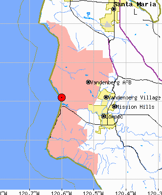
A map showing the position of the Vandenberg AFB coordinates given above. The base is shown in pink. Map courtesy U.S. Census Bureau.
Non-orbital launches (Minuteman III test launches and missile defense tests) take place from northwest Vandenberg. Satellites are usually launched from central or south base.
To determine the azimuth for a location not listed in the table, determine the location's position by going to the Geographic Names Information System:
http://geonames.usgs.gov/pls/gnis/web_query.gnis_web_query_form
Then compute the azimuth using the Javascript Great Circle Calculator:
http://woodshole.er.usgs.gov/staffpages/cpolloni/manitou/ccal.htm
Many rocket and missile launches are easily seen with the naked eye. However, you will see more if you use optical assistance. Binoculars are good, but tripod-mounted binoculars are even better. An astronomical telescope will give the best view and may provide a dynamic, surreal light show.
The author witnessed such a display during the 2002 pre-dawn Delta II/Aqua launch from Vandenberg AFB. Observing with an 8-inch (203mm) Newtonian telescope more than 100 miles (161 km) to the side of the rocket's path, the view was impressive:
"At its maximum development, the first stage engine's plume took up 8/10 of the telescope's field of view. I could see an orange speck (the first stage engine) spraying curved lines - both thick and thin - of light that formed a hemispherical plume.Near the engine, the lines were blue-green in color. Further away, the lines were fainter and white in color. What was really interesting was the motion visible in the plume. Within each line of the plume, there were numerous areas that were brighter than others. I could see these bright areas exit the engine and rapidly travel down the lines and disappear. It was very much like looking at the water droplets spraying from a sprinkler."
1Cloud top data was provided by a forecaster with the National Weather Service Oxnard, California office during a telephone interview on 2004 June 18.
2These are typical values. The actual height of the cloud tops can vary from less than a few hundred feet to up to 5,000 feet (1,524 M).
3Data regarding the frequency of cloud cover was derived from a map of midnight to dawn cloud cover for the months of July and August. Jay Anderson in Observer's Handbook 2002, ed. Rajiv Gupta (Toronto: University of Toronto Press, 2001), p. 59.
4Azimuth data was generated using the following coordinates:
AZ - Flagstaff 35° 11' 53" N, 111° 39' 02" W
AZ - Phoenix 33° 26' 54" N, 112° 04' 24" W
AZ - Tucson 32° 13' 18" N, 110° 55' 33" W
CA - Bakersfield 35° 22' 24" N, 119° 01' 04" W
CA - Fresno 36° 44' 52" N, 119° 46' 17" W
CA - Los Angeles 34° 03' 08" N, 118° 14' 34" W
CA - Monterey 36° 36' 01" N, 121° 53' 37" W
CA - Palm Springs 33° 49' 49" N, 116° 32' 40" W
CA - Ridgecrest 35° 37' 21" N, 117° 40' 12" W
CA - Sacramento 38° 34' 54" N, 121° 29' 36" W
CA - San Bernardino 34° 06' 30" N, 117° 17' 20" W
CA - San Diego 32° 42' 55" N, 117° 09' 23" W
CA - San Francisco 37° 46' 30" N, 122° 25' 06" W
NV - Las Vegas 36° 10' 30" N, 115° 08' 11" W
NV - Reno 39° 31' 47" N, 119° 48' 46"W
UT - Salt Lake City 40° 45' 39" N, 111° 53' 25" W
Copyright © 2001-2018, Brian Webb. All rights reserved.