
Jet Propulsion Laboratory News Release
2023 March 24
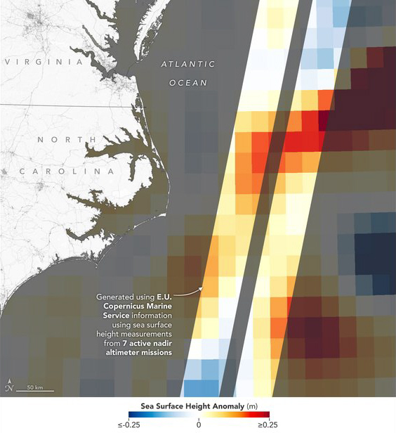
Sea level data gathered Jan. 21 in the Gulf Stream by SWOT's KaRIn instrument, visualized at left, has 10 times the spatial resolution of data taken over the same area by altimeters on seven other satellites, visualized at right. Red represents sea levels higher than the global average, while blue is lower. Credit: left: NASA/JPL-Caltech; right: NASA/JPL-Caltech/Copernicus Marine Service of ESA
The international Surface Water and Ocean Topography (SWOT) mission - led by NASA and the French space agency Centre National d'Etudes Spatiales (CNES) - has sent back some of its first glimpses of water on the planet's surface, showing ocean currents like the Gulf Stream in unprecedented detail. SWOT is also capturing views of freshwater features such as lakes, rivers, and other water bodies down to about 300 feet (100 meters) wide.
The satellite will measure the elevation of nearly all the water on Earth's surface and provide one of the most comprehensive surveys yet of our planet's surface water. SWOT's measurements of freshwater bodies and the ocean will provide insights into how the ocean influences climate change and the water cycle; how a warming world affects water storage in lakes, rivers, and reservoirs; and how communities can better manage their water resources and prepare for floods and other disasters.
"SWOT's advanced imagery will empower researchers and advance the way we manage fresh water and the effects of sea level rise across the globe," said NASA Administrator Bill Nelson. "Water is one of our planet's most important resources - and it's proven to be vulnerable to the impacts of climate change. SWOT will provide critical information that communities can use to prepare for the impacts of a warming climate."
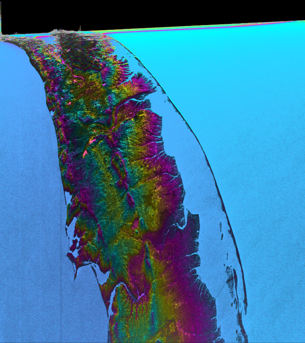
This visualization shows water features on New York's Long Island - shown as bright pink splotches. Purple, yellow, green, and dark blue shades represent different land elevations, while the surrounding ocean is a lighter blue. The data was collected on Jan. 21, 2023, by SWOT's KaRIn instrument. Credit: NASA/JPL-Caltech
A Whole New View
As seen in these early images, on Jan. 21, 2023, SWOT measured sea level in a part of the Gulf Stream off the coast of North Carolina and Virginia. The two antennas of SWOT's Ka-band Radar Interferometer (KaRIn) instrument acquired data that was mapped as a pair of wide, colored strips spanning a total of 75 miles (120 kilometers) across. Red and orange areas in the images represent sea levels that are higher than the global average, while the shades of blue represent sea levels that are lower than average.
For comparison, the new data is shown alongside sea surface height data taken by space-based instruments called altimeters. The instruments - widely used to measure sea level - also bounce radar signals off of Earth's surface to collect their measurements. But traditional altimeters are able to look only at a narrow beam of Earth directly beneath them, unlike KaRIn's two wide-swath strips that observe sea level as a two-dimensional map.
The spatial resolution of SWOT ocean measurements is 10 times greater than the composite of sea surface height data gathered over the same area by seven other satellites: Sentinel-6 Michael Freilich, Jason-3, Sentinel-3A and 3B, Cryosat-2, Altika, and Hai Yang 2B. The composite image was created using information from the Copernicus Marine Service of ESA (European Space Agency) and shows the same day as the SWOT data.
Copyright © 2023, Brian Webb. All rights reserved.